


69 rontalon tr

trietsch
User
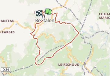

Length
8.4 km

Max alt
618 m

Uphill gradient
292 m
Km-Effort
12.2 km

Min alt
406 m

Downhill gradient
278 m
Boucle
Yes
Creation date :
2022-01-11 08:52:16.0
Updated on :
2022-01-11 11:33:29.682
2h12
Difficulty : Easy

FREE GPS app for hiking
 SityTrail
IGN / Geographical institutes
SityTrail Plus
The world is yours!
About
Trail Walking of 8.4 km to be discovered at Auvergne-Rhône-Alpes, Rhône, Rontalon. This trail is proposed by trietsch.
Positioning
Country:
France
Region :
Auvergne-Rhône-Alpes
Department/Province :
Rhône
Municipality :
Rontalon
Location:
Unknown
Start:(Dec)
Start:(UTM)
627179 ; 5057725 (31T) N.
Comments