


1101

maxEA65
User

Length
4.3 km

Max alt
176 m

Uphill gradient
24 m
Km-Effort
4.6 km

Min alt
161 m

Downhill gradient
21 m
Boucle
No
Creation date :
2022-01-11 15:50:49.343
Updated on :
2022-01-11 16:40:13.345
49m
Difficulty : Easy

FREE GPS app for hiking
 SityTrail
IGN / Geographical institutes
SityTrail Plus
The world is yours!
About
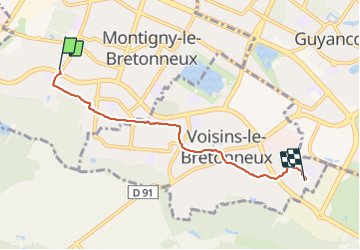
Trail Walking of 4.3 km to be discovered at Ile-de-France, Yvelines, Montigny-le-Bretonneux. This trail is proposed by maxEA65.
Positioning
Country:
France
Region :
Ile-de-France
Department/Province :
Yvelines
Municipality :
Montigny-le-Bretonneux
Location:
Unknown
Start:(Dec)
Start:(UTM)
428165 ; 5402064 (31U) N.
Comments