


1000etangs 09 05 2021 fifi

signorato
User
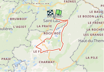

Length
12.3 km

Max alt
708 m

Uphill gradient
378 m
Km-Effort
17.3 km

Min alt
547 m

Downhill gradient
378 m
Boucle
Yes
Creation date :
2021-05-09 08:27:08.937
Updated on :
2022-01-11 20:36:00.642
6h41
Difficulty : Medium

FREE GPS app for hiking
 SityTrail
IGN / Geographical institutes
SityTrail Plus
The world is yours!
About
Trail Walking of 12.3 km to be discovered at Bourgogne-Franche-Comté, Haute-Saône, Beulotte-Saint-Laurent. This trail is proposed by signorato.
Positioning
Country:
France
Region :
Bourgogne-Franche-Comté
Department/Province :
Haute-Saône
Municipality :
Beulotte-Saint-Laurent
Location:
Unknown
Start:(Dec)
Start:(UTM)
326298 ; 5303358 (32T) N.
Comments