


Esterel mimosas

GSananes
User
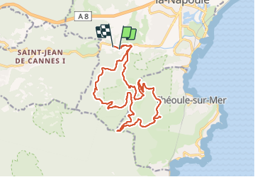

Length
20 km

Max alt
326 m

Uphill gradient
747 m
Km-Effort
30 km

Min alt
16 m

Downhill gradient
733 m
Boucle
No
Creation date :
2022-01-12 07:45:12.837
Updated on :
2022-01-12 21:05:15.72
5h11
Difficulty : Very difficult

FREE GPS app for hiking
 SityTrail
IGN / Geographical institutes
SityTrail Plus
The world is yours!
About
Trail Walking of 20 km to be discovered at Provence-Alpes-Côte d'Azur, Maritime Alps, Mandelieu-la-Napoule. This trail is proposed by GSananes.
Description
Rando faite en janvier 2022.
24 baragnieurs
Positioning
Country:
France
Region :
Provence-Alpes-Côte d'Azur
Department/Province :
Maritime Alps
Municipality :
Mandelieu-la-Napoule
Location:
Unknown
Start:(Dec)
Start:(UTM)
330696 ; 4821139 (32T) N.
Comments