


mercureyAluzeAubigny

mcterret
User
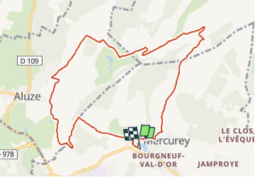

Length
11 km

Max alt
347 m

Uphill gradient
256 m
Km-Effort
14.4 km

Min alt
240 m

Downhill gradient
257 m
Boucle
Yes
Creation date :
2022-01-12 12:50:09.022
Updated on :
2022-01-12 15:37:22.649
2h42
Difficulty : Easy

FREE GPS app for hiking
 SityTrail
IGN / Geographical institutes
SityTrail Plus
The world is yours!
About
Trail Walking of 11 km to be discovered at Bourgogne-Franche-Comté, Saône-et-Loire, Mercurey. This trail is proposed by mcterret.
Positioning
Country:
France
Region :
Bourgogne-Franche-Comté
Department/Province :
Saône-et-Loire
Municipality :
Mercurey
Location:
Unknown
Start:(Dec)
Start:(UTM)
630544 ; 5188637 (31T) N.
Comments