


bouvante truite logues

aldaus
User
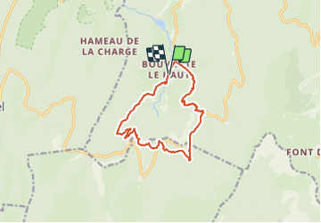

Length
13 km

Max alt
1328 m

Uphill gradient
830 m
Km-Effort
24 km

Min alt
584 m

Downhill gradient
832 m
Boucle
Yes
Creation date :
2022-01-13 09:06:27.788
Updated on :
2022-01-13 14:11:12.4
4h45
Difficulty : Medium

FREE GPS app for hiking
 SityTrail
IGN / Geographical institutes
SityTrail Plus
The world is yours!
About
Trail Walking of 13 km to be discovered at Auvergne-Rhône-Alpes, Drôme, Bouvante. This trail is proposed by aldaus.
Positioning
Country:
France
Region :
Auvergne-Rhône-Alpes
Department/Province :
Drôme
Municipality :
Bouvante
Location:
Unknown
Start:(Dec)
Start:(UTM)
678677 ; 4976583 (31T) N.
Comments