


la vinzelle

bouscaillou
User
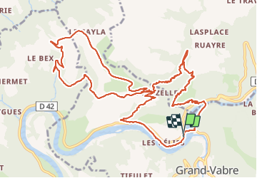

Length
16.4 km

Max alt
580 m

Uphill gradient
631 m
Km-Effort
25 km

Min alt
183 m

Downhill gradient
636 m
Boucle
Yes
Creation date :
2022-01-13 09:07:56.269
Updated on :
2022-01-13 14:38:58.379
5h30
Difficulty : Very difficult

FREE GPS app for hiking
 SityTrail
IGN / Geographical institutes
SityTrail Plus
The world is yours!
About
Trail Walking of 16.4 km to be discovered at Occitania, Aveyron, Conques-en-Rouergue. This trail is proposed by bouscaillou.
Positioning
Country:
France
Region :
Occitania
Department/Province :
Aveyron
Municipality :
Conques-en-Rouergue
Location:
Grand-Vabre
Start:(Dec)
Start:(UTM)
448581 ; 4942707 (31T) N.
Comments