


Trean

Pachinou
User
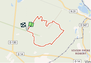

Length
6.3 km

Max alt
141 m

Uphill gradient
144 m
Km-Effort
8.2 km

Min alt
54 m

Downhill gradient
143 m
Boucle
Yes
Creation date :
2022-01-13 13:09:13.336
Updated on :
2022-08-02 08:36:51.353
1h29
Difficulty : Medium

FREE GPS app for hiking
 SityTrail
IGN / Geographical institutes
SityTrail Plus
The world is yours!
About
Trail Walking of 6.3 km to be discovered at Hauts-de-France, Oise, Compiègne. This trail is proposed by Pachinou.
Positioning
Country:
France
Region :
Hauts-de-France
Department/Province :
Oise
Municipality :
Compiègne
Location:
Unknown
Start:(Dec)
Start:(UTM)
491534 ; 5472776 (31U) N.
Comments