


Magrie Gours

Jean Marie Pons
User

Length
21 km

Max alt
394 m

Uphill gradient
567 m
Km-Effort
28 km

Min alt
172 m

Downhill gradient
568 m
Boucle
Yes
Creation date :
2022-01-13 07:52:32.561
Updated on :
2022-01-13 15:57:18.905
5h15
Difficulty : Easy

FREE GPS app for hiking
 SityTrail
IGN / Geographical institutes
SityTrail Plus
The world is yours!
About
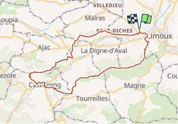
Trail Walking of 21 km to be discovered at Occitania, Aude, Limoux. This trail is proposed by Jean Marie Pons.
Positioning
Country:
France
Region :
Occitania
Department/Province :
Aude
Municipality :
Limoux
Location:
Unknown
Start:(Dec)
Start:(UTM)
435183 ; 4767420 (31T) N.
Comments
randonnée agréable, intéressante en ce jeudi 24-02-22. Le tracé au niveau du château, je ne l'ai pas vu, donc partir vers le lotissement à gauche, puis route. Audier.