


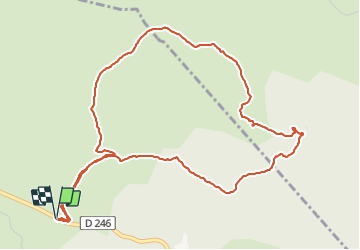
Tour de Font Merdouse

pb07
User

Length
6.1 km

Max alt
263 m

Uphill gradient
81 m
Km-Effort
7.2 km

Min alt
207 m

Downhill gradient
81 m
Boucle
Yes
Creation date :
2022-01-13 12:56:09.389
Updated on :
2022-01-13 15:58:39.89
3h02
Difficulty : Medium

FREE GPS app for hiking
 SityTrail
IGN / Geographical institutes
SityTrail Plus
The world is yours!
About
Trail Walking of 6.1 km to be discovered at Auvergne-Rhône-Alpes, Ardèche, Lablachère. This trail is proposed by pb07.
Positioning
Country:
France
Region :
Auvergne-Rhône-Alpes
Department/Province :
Ardèche
Municipality :
Lablachère
Location:
Unknown
Start:(Dec)
Start:(UTM)
598689 ; 4922205 (31T) N.
Comments