


gaujac

mesrandos
User
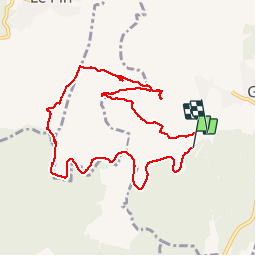

Length
10.5 km

Max alt
280 m

Uphill gradient
195 m
Km-Effort
13.1 km

Min alt
121 m

Downhill gradient
200 m
Boucle
No
Creation date :
2014-12-10 00:00:00.0
Updated on :
2014-12-10 00:00:00.0
2h56
Difficulty : Easy

FREE GPS app for hiking
 SityTrail
IGN / Geographical institutes
SityTrail Plus
The world is yours!
About
Trail Walking of 10.5 km to be discovered at Occitania, Gard, Gaujac. This trail is proposed by mesrandos.
Description
opidum
Positioning
Country:
France
Region :
Occitania
Department/Province :
Gard
Municipality :
Gaujac
Location:
Unknown
Start:(Dec)
Start:(UTM)
625305 ; 4881061 (31T) N.
Comments
A partir de l'oppidium il vaut mieux redescendre par la route normale. Le parcours tracé à partir de ce site débouche sur un ruisseau asséché pierreux difficile à franchir.