


220116 Saint-Denis les Sens

Specialized77
User GUIDE

Length
10.4 km

Max alt
69 m

Uphill gradient
49 m
Km-Effort
11.1 km

Min alt
52 m

Downhill gradient
49 m
Boucle
Yes
Creation date :
2022-01-16 08:02:37.13
Updated on :
2022-01-16 11:12:09.134
3h08
Difficulty : Very easy

FREE GPS app for hiking
 SityTrail
IGN / Geographical institutes
SityTrail Plus
The world is yours!
About
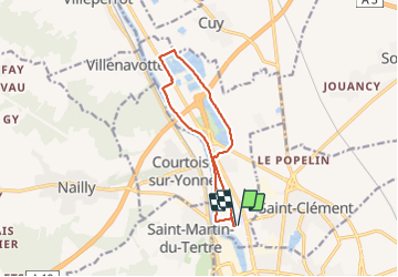
Trail Walking of 10.4 km to be discovered at Bourgogne-Franche-Comté, Yonne, Saint-Denis-lès-Sens. This trail is proposed by Specialized77.
Positioning
Country:
France
Region :
Bourgogne-Franche-Comté
Department/Province :
Yonne
Municipality :
Saint-Denis-lès-Sens
Location:
Unknown
Start:(Dec)
Start:(UTM)
520232 ; 5340210 (31U) N.
Comments