


silly le lonh

gr-gd
User
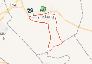

Length
6.5 km

Max alt
126 m

Uphill gradient
42 m
Km-Effort
7.1 km

Min alt
97 m

Downhill gradient
48 m
Boucle
No
Creation date :
2022-01-20 08:31:27.433
Updated on :
2022-01-20 10:42:22.955
2h08
Difficulty : Medium

FREE GPS app for hiking
 SityTrail
IGN / Geographical institutes
SityTrail Plus
The world is yours!
About
Trail Walking of 6.5 km to be discovered at Hauts-de-France, Oise, Silly-le-Long. This trail is proposed by gr-gd.
Description
très bouseux
Positioning
Country:
France
Region :
Hauts-de-France
Department/Province :
Oise
Municipality :
Silly-le-Long
Location:
Unknown
Start:(Dec)
Start:(UTM)
484397 ; 5439304 (31U) N.
Comments