


chemin des croix

Louna
User

Length
11.4 km

Max alt
889 m

Uphill gradient
515 m
Km-Effort
18.3 km

Min alt
448 m

Downhill gradient
543 m
Boucle
Yes
Creation date :
2022-01-20 09:47:07.245
Updated on :
2022-01-20 12:21:51.198
2h18
Difficulty : Difficult

FREE GPS app for hiking
 SityTrail
IGN / Geographical institutes
SityTrail Plus
The world is yours!
About
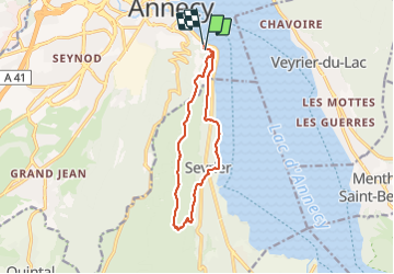
Trail Walking of 11.4 km to be discovered at Auvergne-Rhône-Alpes, Upper Savoy, Annecy. This trail is proposed by Louna .
Positioning
Country:
France
Region :
Auvergne-Rhône-Alpes
Department/Province :
Upper Savoy
Municipality :
Annecy
Location:
Annecy
Start:(Dec)
Start:(UTM)
278068 ; 5085819 (32T) N.
Comments