


mimosas Tanneron après midi

bernir
User
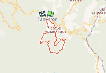

Length
7.3 km

Max alt
408 m

Uphill gradient
220 m
Km-Effort
10.2 km

Min alt
220 m

Downhill gradient
215 m
Boucle
Yes
Creation date :
2022-01-20 10:33:03.204
Updated on :
2022-01-21 11:15:45.041
4h12
Difficulty : Medium

FREE GPS app for hiking
 SityTrail
IGN / Geographical institutes
SityTrail Plus
The world is yours!
About
Trail Walking of 7.3 km to be discovered at Provence-Alpes-Côte d'Azur, Var, Tanneron. This trail is proposed by bernir.
Positioning
Country:
France
Region :
Provence-Alpes-Côte d'Azur
Department/Province :
Var
Municipality :
Tanneron
Location:
Unknown
Start:(Dec)
Start:(UTM)
328467 ; 4828504 (32T) N.
Comments