


col de la boite

jphugon
User

Length
15.7 km

Max alt
562 m

Uphill gradient
593 m
Km-Effort
24 km

Min alt
254 m

Downhill gradient
587 m
Boucle
Yes
Creation date :
2022-01-20 08:24:00.511
Updated on :
2022-01-20 15:25:06.785
7h00
Difficulty : Very difficult

FREE GPS app for hiking
 SityTrail
IGN / Geographical institutes
SityTrail Plus
The world is yours!
About
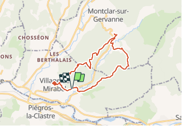
Trail Walking of 15.7 km to be discovered at Auvergne-Rhône-Alpes, Drôme, Mirabel-et-Blacons. This trail is proposed by jphugon.
Positioning
Country:
France
Region :
Auvergne-Rhône-Alpes
Department/Province :
Drôme
Municipality :
Mirabel-et-Blacons
Location:
Unknown
Start:(Dec)
Start:(UTM)
667855 ; 4953079 (31T) N.
Comments