


fonties

elexine23
User
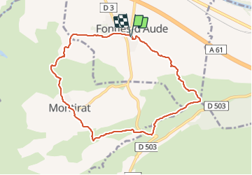

Length
9.4 km

Max alt
220 m

Uphill gradient
219 m
Km-Effort
12.3 km

Min alt
99 m

Downhill gradient
219 m
Boucle
Yes
Creation date :
2022-01-20 12:47:39.006
Updated on :
2022-01-20 16:12:27.861
2h35
Difficulty : Very easy

FREE GPS app for hiking
 SityTrail
IGN / Geographical institutes
SityTrail Plus
The world is yours!
About
Trail Walking of 9.4 km to be discovered at Occitania, Aude, Fontiès-d'Aude. This trail is proposed by elexine23.
Positioning
Country:
France
Region :
Occitania
Department/Province :
Aude
Municipality :
Fontiès-d'Aude
Location:
Unknown
Start:(Dec)
Start:(UTM)
455669 ; 4781543 (31T) N.
Comments