


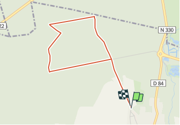
RS_VER-sur-LAUNETTE (BOIS D'HYVER)_4km
GOELE RANDO
Randonner avec bonne humeur et convivialité. (Inscription réservée uniquement aux animateurs de GOËLE RANDO)


1h00
Difficulty : Easy

FREE GPS app for hiking
 SityTrail
IGN / Geographical institutes
SityTrail Plus
The world is yours!
About
Trail On foot of 4 km to be discovered at Hauts-de-France, Oise, Ver-sur-Launette. This trail is proposed by GOELE RANDO.
Description
https://www.goelerando.fr/ - DAMMARTIN en GOËLE 77230 -
Photos
_4km - Photo 1")
Positioning
Comments