


Caluire st clair

ppn
User
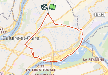

Length
8.4 km

Max alt
284 m

Uphill gradient
143 m
Km-Effort
10.3 km

Min alt
166 m

Downhill gradient
144 m
Boucle
Yes
Creation date :
2022-01-21 12:45:14.702
Updated on :
2022-01-21 14:59:57.487
2h13
Difficulty : Medium

FREE GPS app for hiking
 SityTrail
IGN / Geographical institutes
SityTrail Plus
The world is yours!
About
Trail Walking of 8.4 km to be discovered at Auvergne-Rhône-Alpes, Métropole de Lyon, Caluire-et-Cuire. This trail is proposed by ppn.
Positioning
Country:
France
Region :
Auvergne-Rhône-Alpes
Department/Province :
Métropole de Lyon
Municipality :
Caluire-et-Cuire
Location:
Unknown
Start:(Dec)
Start:(UTM)
644382 ; 5074249 (31T) N.
Comments