


SityTrail - 3061378 - orban-chemin-des-cretes

chripaci
User

Length
5.9 km

Max alt
249 m

Uphill gradient
119 m
Km-Effort
7.5 km

Min alt
200 m

Downhill gradient
118 m
Boucle
Yes
Creation date :
2022-01-23 13:21:05.0
Updated on :
2022-01-24 16:48:26.236
1h42
Difficulty : Medium

FREE GPS app for hiking
 SityTrail
IGN / Geographical institutes
SityTrail Plus
The world is yours!
About
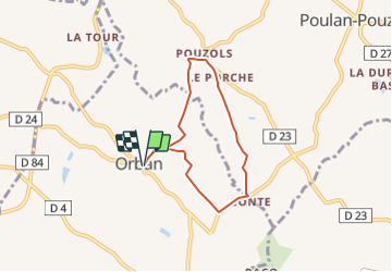
Trail Walking of 5.9 km to be discovered at Occitania, Tarn, Orban. This trail is proposed by chripaci.
Description
promenade facile sur les douces rondeurs du paysage entre Orban et Pouzols. Peu de bitume et de jolis chemins entre champs
Photos


Positioning
Country:
France
Region :
Occitania
Department/Province :
Tarn
Municipality :
Orban
Location:
Unknown
Start:(Dec)
Start:(UTM)
426306 ; 4854819 (31T) N.
Comments