


col de Vassieux-Col de la Chaud

lionelnottat
User
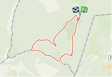

Length
8 km

Max alt
1438 m

Uphill gradient
278 m
Km-Effort
11.7 km

Min alt
1214 m

Downhill gradient
277 m
Boucle
Yes
Creation date :
2022-01-24 09:35:58.383
Updated on :
2022-01-24 09:36:43.98
--
Difficulty : Medium

FREE GPS app for hiking
 SityTrail
IGN / Geographical institutes
SityTrail Plus
The world is yours!
About
Trail Snowshoes of 8 km to be discovered at Auvergne-Rhône-Alpes, Drôme, Vassieux-en-Vercors. This trail is proposed by lionelnottat.
Positioning
Country:
France
Region :
Auvergne-Rhône-Alpes
Department/Province :
Drôme
Municipality :
Vassieux-en-Vercors
Location:
Unknown
Start:(Dec)
Start:(UTM)
687418 ; 4968554 (31T) N.
Comments