


2022-01-24 Forêt de Montmorency

Bernardb44
User
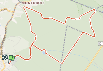

Length
7.3 km

Max alt
194 m

Uphill gradient
140 m
Km-Effort
9.2 km

Min alt
129 m

Downhill gradient
138 m
Boucle
Yes
Creation date :
2022-01-24 09:39:06.936
Updated on :
2022-01-24 11:12:24.52
1h32
Difficulty : Easy

FREE GPS app for hiking
 SityTrail
IGN / Geographical institutes
SityTrail Plus
The world is yours!
About
Trail Walking of 7.3 km to be discovered at Ile-de-France, Val-d'Oise, Taverny. This trail is proposed by Bernardb44.
Positioning
Country:
France
Region :
Ile-de-France
Department/Province :
Val-d'Oise
Municipality :
Taverny
Location:
Unknown
Start:(Dec)
Start:(UTM)
443483 ; 5431135 (31U) N.
Comments