


Rosières fontaines

pb07
User
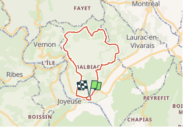

Length
14.1 km

Max alt
383 m

Uphill gradient
335 m
Km-Effort
18.5 km

Min alt
152 m

Downhill gradient
335 m
Boucle
Yes
Creation date :
2022-01-24 09:12:03.688
Updated on :
2022-01-24 15:27:41.558
4h25
Difficulty : Difficult

FREE GPS app for hiking
 SityTrail
IGN / Geographical institutes
SityTrail Plus
The world is yours!
About
Trail Walking of 14.1 km to be discovered at Auvergne-Rhône-Alpes, Ardèche, Rosières. This trail is proposed by pb07.
Positioning
Country:
France
Region :
Auvergne-Rhône-Alpes
Department/Province :
Ardèche
Municipality :
Rosières
Location:
Unknown
Start:(Dec)
Start:(UTM)
599797 ; 4926203 (31T) N.
Comments