


la boucle de la feuille

Mascart
User
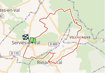

Length
12 km

Max alt
290 m

Uphill gradient
240 m
Km-Effort
15.1 km

Min alt
169 m

Downhill gradient
228 m
Boucle
Yes
Creation date :
2022-01-25 11:14:27.602
Updated on :
2022-01-25 20:03:07.744
4h00
Difficulty : Medium

FREE GPS app for hiking
 SityTrail
IGN / Geographical institutes
SityTrail Plus
The world is yours!
About
Trail Walking of 12 km to be discovered at Occitania, Aude, Serviès-en-Val. This trail is proposed by Mascart.
Description
départ de Servies en val
Positioning
Country:
France
Region :
Occitania
Department/Province :
Aude
Municipality :
Serviès-en-Val
Location:
Unknown
Start:(Dec)
Start:(UTM)
460884 ; 4770713 (31T) N.
Comments