


St Adrien- Chemin de la Source

JMCMoreau
User
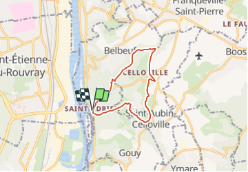

Length
9.7 km

Max alt
153 m

Uphill gradient
211 m
Km-Effort
12.5 km

Min alt
8 m

Downhill gradient
207 m
Boucle
Yes
Creation date :
2022-01-26 09:11:35.707
Updated on :
2022-01-26 09:13:40.009
3h00
Difficulty : Easy

FREE GPS app for hiking
 SityTrail
IGN / Geographical institutes
SityTrail Plus
The world is yours!
About
Trail Walking of 9.7 km to be discovered at Normandy, Seine-Maritime, Belbeuf. This trail is proposed by JMCMoreau.
Positioning
Country:
France
Region :
Normandy
Department/Province :
Seine-Maritime
Municipality :
Belbeuf
Location:
Unknown
Start:(Dec)
Start:(UTM)
364166 ; 5470117 (31U) N.
Comments