


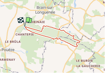
Tour de la Forêt Domaniale de Longuenée

Association ARCA49
Autour de la randonnée

Length
12.6 km

Max alt
109 m

Uphill gradient
91 m
Km-Effort
13.8 km

Min alt
83 m

Downhill gradient
91 m
Boucle
Yes
Creation date :
2022-01-26 14:51:12.43
Updated on :
2022-04-05 13:04:01.965
3h08
Difficulty : Difficult

FREE GPS app for hiking
 SityTrail
IGN / Geographical institutes
SityTrail Plus
The world is yours!
About
Trail Walking of 12.6 km to be discovered at Pays de la Loire, Maine-et-Loire, Erdre-en-Anjou. This trail is proposed by Association ARCA49.
Positioning
Country:
France
Region :
Pays de la Loire
Department/Province :
Maine-et-Loire
Municipality :
Erdre-en-Anjou
Location:
Brain-sur-Longuenée
Start:(Dec)
Start:(UTM)
666527 ; 5270964 (30T) N.
Comments