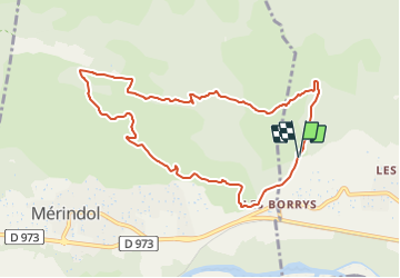
Mérindol - les Borrys

Berpav
User

Length
9.6 km

Max alt
336 m

Uphill gradient
322 m
Km-Effort
13.9 km

Min alt
144 m

Downhill gradient
318 m
Boucle
Yes
Creation date :
2022-01-26 16:11:53.114
Updated on :
2022-01-30 17:35:28.73
3h04
Difficulty : Difficult

FREE GPS app for hiking
 SityTrail
IGN / Geographical institutes
SityTrail Plus
The world is yours!
About
Trail Walking of 9.6 km to be discovered at Provence-Alpes-Côte d'Azur, Vaucluse, Puget. This trail is proposed by Berpav.
Positioning
Country:
France
Region :
Provence-Alpes-Côte d'Azur
Department/Province :
Vaucluse
Municipality :
Puget
Location:
Unknown
Start:(Dec)
Start:(UTM)
680218 ; 4847868 (31T) N.
Comments