


correns

vincente204
User
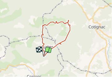

Length
11.8 km

Max alt
470 m

Uphill gradient
275 m
Km-Effort
15.4 km

Min alt
269 m

Downhill gradient
274 m
Boucle
Yes
Creation date :
2022-01-27 08:30:57.162
Updated on :
2022-01-27 13:04:42.302
4h33
Difficulty : Difficult

FREE GPS app for hiking
 SityTrail
IGN / Geographical institutes
SityTrail Plus
The world is yours!
About
Trail Walking of 11.8 km to be discovered at Provence-Alpes-Côte d'Azur, Var, Correns. This trail is proposed by vincente204.
Positioning
Country:
France
Region :
Provence-Alpes-Côte d'Azur
Department/Province :
Var
Municipality :
Correns
Location:
Unknown
Start:(Dec)
Start:(UTM)
264904 ; 4820849 (32T) N.
Comments