


Eglise St Etienne Montchaboud

lionelnottat
User
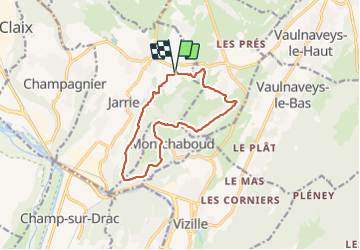

Length
11.9 km

Max alt
738 m

Uphill gradient
472 m
Km-Effort
18.2 km

Min alt
356 m

Downhill gradient
470 m
Boucle
Yes
Creation date :
2022-01-27 08:13:01.339
Updated on :
2022-01-27 13:16:47.724
3h25
Difficulty : Difficult

FREE GPS app for hiking
 SityTrail
IGN / Geographical institutes
SityTrail Plus
The world is yours!
About
Trail Walking of 11.9 km to be discovered at Auvergne-Rhône-Alpes, Isère, Jarrie. This trail is proposed by lionelnottat.
Positioning
Country:
France
Region :
Auvergne-Rhône-Alpes
Department/Province :
Isère
Municipality :
Jarrie
Location:
Unknown
Start:(Dec)
Start:(UTM)
717613 ; 4999179 (31T) N.
Comments