


Torcy

Jupode
User

Length
10.5 km

Max alt
167 m

Uphill gradient
178 m
Km-Effort
12.9 km

Min alt
86 m

Downhill gradient
175 m
Boucle
Yes
Creation date :
2022-01-27 12:50:40.997
Updated on :
2022-01-27 15:21:52.434
2h30
Difficulty : Difficult

FREE GPS app for hiking
 SityTrail
IGN / Geographical institutes
SityTrail Plus
The world is yours!
About
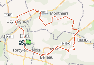
Trail Walking of 10.5 km to be discovered at Hauts-de-France, Aisne, Torcy-en-Valois. This trail is proposed by Jupode.
Positioning
Country:
France
Region :
Hauts-de-France
Department/Province :
Aisne
Municipality :
Torcy-en-Valois
Location:
Unknown
Start:(Dec)
Start:(UTM)
520349 ; 5437268 (31U) N.
Comments