


Trou de Chalvet

RobinMicheline
User GUIDE
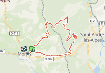

Length
11.8 km

Max alt
1605 m

Uphill gradient
742 m
Km-Effort
22 km

Min alt
909 m

Downhill gradient
742 m
Boucle
Yes
Creation date :
2022-01-27 16:34:46.547
Updated on :
2022-01-27 16:41:54.376
4h56
Difficulty : Very difficult

FREE GPS app for hiking
 SityTrail
IGN / Geographical institutes
SityTrail Plus
The world is yours!
About
Trail Walking of 11.8 km to be discovered at Provence-Alpes-Côte d'Azur, Alpes-de-Haute-Provence, Moriez. This trail is proposed by RobinMicheline.
Positioning
Country:
France
Region :
Provence-Alpes-Côte d'Azur
Department/Province :
Alpes-de-Haute-Provence
Municipality :
Moriez
Location:
Unknown
Start:(Dec)
Start:(UTM)
297125 ; 4870685 (32T) N.
Comments