


fontaine zone humide des prollieres

ppn
User
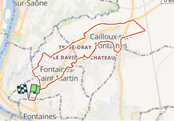

Length
10.3 km

Max alt
267 m

Uphill gradient
115 m
Km-Effort
11.8 km

Min alt
186 m

Downhill gradient
115 m
Boucle
Yes
Creation date :
2022-01-28 12:37:44.929
Updated on :
2022-01-28 15:25:04.636
2h45
Difficulty : Medium

FREE GPS app for hiking
 SityTrail
IGN / Geographical institutes
SityTrail Plus
The world is yours!
About
Trail Walking of 10.3 km to be discovered at Auvergne-Rhône-Alpes, Métropole de Lyon, Fontaines-sur-Saône. This trail is proposed by ppn.
Positioning
Country:
France
Region :
Auvergne-Rhône-Alpes
Department/Province :
Métropole de Lyon
Municipality :
Fontaines-sur-Saône
Location:
Unknown
Start:(Dec)
Start:(UTM)
643245 ; 5077683 (31T) N.
Comments