


Fontête

Clo0413
User

Length
6 km

Max alt
818 m

Uphill gradient
383 m
Km-Effort
11.1 km

Min alt
440 m

Downhill gradient
379 m
Boucle
Yes
Creation date :
2022-01-28 13:33:16.198
Updated on :
2022-01-28 21:41:12.275
1h35
Difficulty : Easy

FREE GPS app for hiking
 SityTrail
IGN / Geographical institutes
SityTrail Plus
The world is yours!
About
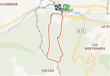
Trail Walking of 6 km to be discovered at Provence-Alpes-Côte d'Azur, Alpes-de-Haute-Provence, Malijai. This trail is proposed by Clo0413.
Positioning
Country:
France
Region :
Provence-Alpes-Côte d'Azur
Department/Province :
Alpes-de-Haute-Provence
Municipality :
Malijai
Location:
Unknown
Start:(Dec)
Start:(UTM)
261949 ; 4880943 (32T) N.
Comments