


Moret S28

jcm17
User
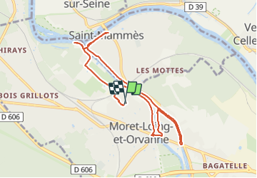

Length
8.8 km

Max alt
54 m

Uphill gradient
50 m
Km-Effort
9.5 km

Min alt
37 m

Downhill gradient
50 m
Boucle
Yes
Creation date :
2022-01-28 15:19:43.385
Updated on :
2022-01-28 17:03:52.104
1h41
Difficulty : Medium

FREE GPS app for hiking
 SityTrail
IGN / Geographical institutes
SityTrail Plus
The world is yours!
About
Trail Walking of 8.8 km to be discovered at Ile-de-France, Seine-et-Marne, Moret-Loing-et-Orvanne. This trail is proposed by jcm17.
Description
Moret S28
Positioning
Country:
France
Region :
Ile-de-France
Department/Province :
Seine-et-Marne
Municipality :
Moret-Loing-et-Orvanne
Location:
Veneux-les-Sablons
Start:(Dec)
Start:(UTM)
486076 ; 5358278 (31U) N.
Comments