


deart ledesert; rocher du pertuis et d'ardison

gerardmicheline
User

Length
16.5 km

Max alt
1474 m

Uphill gradient
1073 m
Km-Effort
31 km

Min alt
591 m

Downhill gradient
1080 m
Boucle
Yes
Creation date :
2022-01-29 15:40:19.956
Updated on :
2022-01-29 15:41:24.795
7h00
Difficulty : Very difficult

FREE GPS app for hiking
 SityTrail
IGN / Geographical institutes
SityTrail Plus
The world is yours!
About
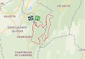
Trail Walking of 16.5 km to be discovered at Auvergne-Rhône-Alpes, Isère, Saint-Laurent-du-Pont. This trail is proposed by gerardmicheline.
Positioning
Country:
France
Region :
Auvergne-Rhône-Alpes
Department/Province :
Isère
Municipality :
Saint-Laurent-du-Pont
Location:
Unknown
Start:(Dec)
Start:(UTM)
715971 ; 5030365 (31T) N.
Comments