


grotte du renard

lablaquiere
User
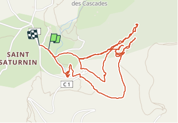

Length
4.1 km

Max alt
651 m

Uphill gradient
260 m
Km-Effort
7.5 km

Min alt
476 m

Downhill gradient
260 m
Boucle
Yes
Creation date :
2022-01-29 14:19:28.602
Updated on :
2022-01-29 16:45:26.628
1h38
Difficulty : Medium

FREE GPS app for hiking
 SityTrail
IGN / Geographical institutes
SityTrail Plus
The world is yours!
About
Trail Walking of 4.1 km to be discovered at Occitania, Aveyron, Creissels. This trail is proposed by lablaquiere.
Positioning
Country:
France
Region :
Occitania
Department/Province :
Aveyron
Municipality :
Creissels
Location:
Unknown
Start:(Dec)
Start:(UTM)
504729 ; 4880595 (31T) N.
Comments