


puyloubier

ARPF1
User
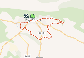

Length
7.9 km

Max alt
364 m

Uphill gradient
130 m
Km-Effort
9.6 km

Min alt
287 m

Downhill gradient
127 m
Boucle
Yes
Creation date :
2022-01-30 12:55:56.472
Updated on :
2022-01-30 14:58:14.687
2h01
Difficulty : Medium

FREE GPS app for hiking
 SityTrail
IGN / Geographical institutes
SityTrail Plus
The world is yours!
About
Trail Walking of 7.9 km to be discovered at Provence-Alpes-Côte d'Azur, Bouches-du-Rhône, Puyloubier. This trail is proposed by ARPF1.
Description
sentier des vignerons
Positioning
Country:
France
Region :
Provence-Alpes-Côte d'Azur
Department/Province :
Bouches-du-Rhône
Municipality :
Puyloubier
Location:
Unknown
Start:(Dec)
Start:(UTM)
715885 ; 4822560 (31T) N.
Comments