


depart col du cucheron grand som

gerardmicheline
User
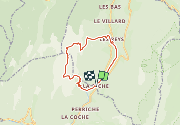

Length
13 km

Max alt
2012 m

Uphill gradient
1180 m
Km-Effort
29 km

Min alt
918 m

Downhill gradient
1186 m
Boucle
Yes
Creation date :
2022-01-30 15:45:37.659
Updated on :
2022-01-30 15:46:26.725
6h31
Difficulty : Very difficult

FREE GPS app for hiking
 SityTrail
IGN / Geographical institutes
SityTrail Plus
The world is yours!
About
Trail Walking of 13 km to be discovered at Auvergne-Rhône-Alpes, Isère, Saint-Pierre-d'Entremont. This trail is proposed by gerardmicheline.
Positioning
Country:
France
Region :
Auvergne-Rhône-Alpes
Department/Province :
Isère
Municipality :
Saint-Pierre-d'Entremont
Location:
Unknown
Start:(Dec)
Start:(UTM)
721940 ; 5027504 (31T) N.
Comments