


2022-02-02_18h48m54_Mullerthal_Trail_Route_2 (1)

DomF
User
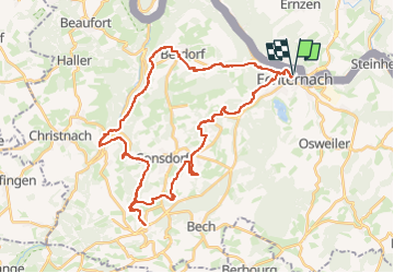

Length
39 km

Max alt
395 m

Uphill gradient
975 m
Km-Effort
52 km

Min alt
164 m

Downhill gradient
975 m
Boucle
Yes
Creation date :
2022-02-02 17:48:54.215
Updated on :
2024-04-05 07:45:51.058
3h35
Difficulty : Very difficult

FREE GPS app for hiking
 SityTrail
IGN / Geographical institutes
SityTrail Plus
The world is yours!
About
Trail Mountain bike of 39 km to be discovered at Unknown, Canton Echternach, Echternach. This trail is proposed by DomF.
Positioning
Country:
Luxembourg
Region :
Unknown
Department/Province :
Canton Echternach
Municipality :
Echternach
Location:
Unknown
Start:(Dec)
Start:(UTM)
314480 ; 5521097 (32U) N.
Comments