


sortie avec Étienne

bernardcornu
User
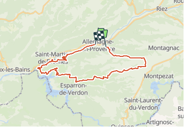

Length
33 km

Max alt
600 m

Uphill gradient
685 m
Km-Effort
42 km

Min alt
376 m

Downhill gradient
672 m
Boucle
No
Creation date :
2022-02-03 12:49:38.154
Updated on :
2022-02-03 14:59:47.213
1h59
Difficulty : Medium

FREE GPS app for hiking
 SityTrail
IGN / Geographical institutes
SityTrail Plus
The world is yours!
About
Trail Mountain bike of 33 km to be discovered at Provence-Alpes-Côte d'Azur, Alpes-de-Haute-Provence, Allemagne-en-Provence. This trail is proposed by bernardcornu.
Positioning
Country:
France
Region :
Provence-Alpes-Côte d'Azur
Department/Province :
Alpes-de-Haute-Provence
Municipality :
Allemagne-en-Provence
Location:
Unknown
Start:(Dec)
Start:(UTM)
258870 ; 4852058 (32T) N.
Comments