


Saint Sulpice fait 2022

pidjam
User
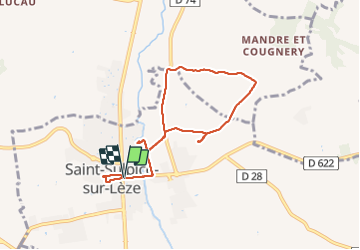

Length
7.8 km

Max alt
271 m

Uphill gradient
106 m
Km-Effort
9.2 km

Min alt
193 m

Downhill gradient
105 m
Boucle
Yes
Creation date :
2022-02-03 13:07:58.778
Updated on :
2022-02-03 15:35:00.781
2h08
Difficulty : Medium

FREE GPS app for hiking
 SityTrail
IGN / Geographical institutes
SityTrail Plus
The world is yours!
About
Trail Walking of 7.8 km to be discovered at Occitania, Haute-Garonne, Saint-Sulpice-sur-Lèze. This trail is proposed by pidjam.
Positioning
Country:
France
Region :
Occitania
Department/Province :
Haute-Garonne
Municipality :
Saint-Sulpice-sur-Lèze
Location:
Unknown
Start:(Dec)
Start:(UTM)
364009 ; 4798648 (31T) N.
Comments