


les borrys 2

Berpav
User
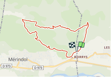

Length
10.2 km

Max alt
335 m

Uphill gradient
324 m
Km-Effort
14.5 km

Min alt
144 m

Downhill gradient
325 m
Boucle
Yes
Creation date :
2022-02-03 12:56:57.9
Updated on :
2022-02-03 15:54:07.489
2h32
Difficulty : Difficult

FREE GPS app for hiking
 SityTrail
IGN / Geographical institutes
SityTrail Plus
The world is yours!
About
Trail Walking of 10.2 km to be discovered at Provence-Alpes-Côte d'Azur, Vaucluse, Puget. This trail is proposed by Berpav.
Positioning
Country:
France
Region :
Provence-Alpes-Côte d'Azur
Department/Province :
Vaucluse
Municipality :
Puget
Location:
Unknown
Start:(Dec)
Start:(UTM)
679961 ; 4847509 (31T) N.
Comments