


chemin du fort des Épesses.

dcharbonnier
User
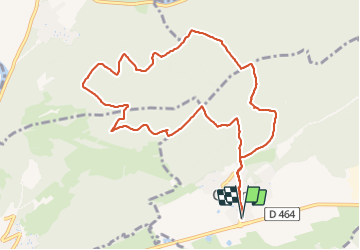

Length
10.7 km

Max alt
576 m

Uphill gradient
300 m
Km-Effort
14.7 km

Min alt
388 m

Downhill gradient
300 m
Boucle
Yes
Creation date :
2022-02-03 12:31:11.957
Updated on :
2022-02-03 16:18:01.534
3h45
Difficulty : Medium

FREE GPS app for hiking
 SityTrail
IGN / Geographical institutes
SityTrail Plus
The world is yours!
About
Trail Walking of 10.7 km to be discovered at Bourgogne-Franche-Comté, Doubs, Gennes. This trail is proposed by dcharbonnier.
Description
départ de Gennes parking de la salle polyvalente.
1 passage délicat en descente par temps humide.
Positioning
Country:
France
Region :
Bourgogne-Franche-Comté
Department/Province :
Doubs
Municipality :
Gennes
Location:
Unknown
Start:(Dec)
Start:(UTM)
282333 ; 5235982 (32T) N.
Comments