


Crêt de chalam. fait le 3/2/2022

gerardmicheline
User
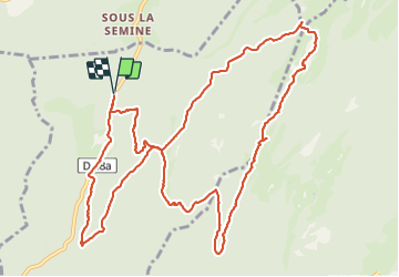

Length
14.2 km

Max alt
1524 m

Uphill gradient
720 m
Km-Effort
24 km

Min alt
1057 m

Downhill gradient
720 m
Boucle
Yes
Creation date :
2022-02-03 08:31:07.589
Updated on :
2022-02-03 16:21:14.034
5h08
Difficulty : Very difficult

FREE GPS app for hiking
 SityTrail
IGN / Geographical institutes
SityTrail Plus
The world is yours!
About
Trail Snowshoes of 14.2 km to be discovered at Auvergne-Rhône-Alpes, Ain, Champfromier. This trail is proposed by gerardmicheline.
Positioning
Country:
France
Region :
Auvergne-Rhône-Alpes
Department/Province :
Ain
Municipality :
Champfromier
Location:
Unknown
Start:(Dec)
Start:(UTM)
718868 ; 5126593 (31T) N.
Comments