


G3 - La Ruchère

lionelnottat
User
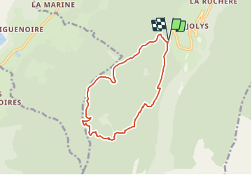

Length
6.9 km

Max alt
1362 m

Uphill gradient
307 m
Km-Effort
11 km

Min alt
1162 m

Downhill gradient
308 m
Boucle
Yes
Creation date :
2022-02-04 16:04:17.748
Updated on :
2022-02-04 16:05:24.819
--
Difficulty : Medium

FREE GPS app for hiking
 SityTrail
IGN / Geographical institutes
SityTrail Plus
The world is yours!
About
Trail Snowshoes of 6.9 km to be discovered at Auvergne-Rhône-Alpes, Isère, Saint-Christophe-sur-Guiers. This trail is proposed by lionelnottat.
Positioning
Country:
France
Region :
Auvergne-Rhône-Alpes
Department/Province :
Isère
Municipality :
Saint-Christophe-sur-Guiers
Location:
Unknown
Start:(Dec)
Start:(UTM)
718854 ; 5032172 (31T) N.
Comments