


Villeneuve-sur-Fère du 05-02-2022

VANDERPUTTENMi
User GUIDE
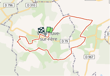

Length
9.3 km

Max alt
219 m

Uphill gradient
161 m
Km-Effort
11.4 km

Min alt
141 m

Downhill gradient
161 m
Boucle
Yes
Creation date :
2022-02-05 08:41:45.883
Updated on :
2022-02-05 14:02:46.745
2h15
Difficulty : Medium

FREE GPS app for hiking
 SityTrail
IGN / Geographical institutes
SityTrail Plus
The world is yours!
About
Trail Walking of 9.3 km to be discovered at Hauts-de-France, Aisne, Villeneuve-sur-Fère. This trail is proposed by VANDERPUTTENMi.
Photos

Positioning
Country:
France
Region :
Hauts-de-France
Department/Province :
Aisne
Municipality :
Villeneuve-sur-Fère
Location:
Unknown
Start:(Dec)
Start:(UTM)
534554 ; 5447358 (31U) N.
Comments