Trail On foot Sainte-Gemme - 2022-02-05_16h42m32_Cirkwi-Sentier__Lo_Camìn_del_Carboniers__-_chemin_des_paysans_mineurs - Photo

2022-02-05_16h42m32_Cirkwi-Sentier__Lo_Camìn_del_Carboniers__-_chemin_des_paysans_mineurs

 tercla
tercla

User

© OpenStreetMap contributors
Length
Length
10 km
Max alt
Max alt
361 m
Uphill gradient
Uphill gradient
256 m
Km-Effort
Km-Effort  
13.4 km
Min alt
Min alt
272 m
Downhill gradient
Downhill gradient
256 m
Boucle
Boucle
Yes
Creation date :
2022-02-05 15:42:32.723
Updated on :
2022-02-11 06:20:59.209

(0 Reviews)

On foot
On foot
3h02
Difficulty : Easy

Scan this QR Code to open this trail in the SityTrail application

FREE GPS app for hiking

Logo SityTrail SityTrail

IGN / Geographical institutes

Download SityTrail from the App Store Download SityTrail from Google Play

Logo SityTrail SityTrail World

The world is yours!

Download SityTrail from the App Store Download SityTrail from Google Play Download SityTrail on Huawei AppGallery

About

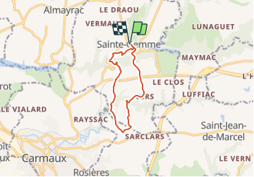
Trail On foot of 10 km to be discovered at Occitania, Tarn, Sainte-Gemme. This trail is proposed by tercla.

Description

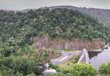
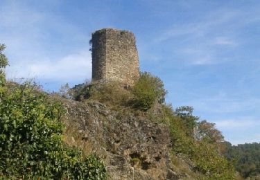
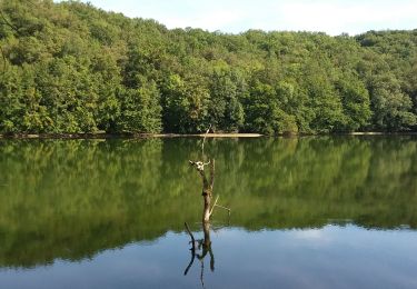
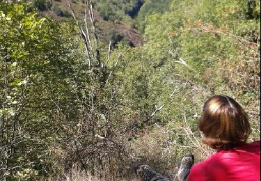
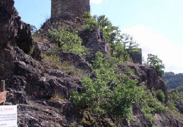
ATTENTION : 02.21 suite à des inondations, le parcours n'est plus réalisable dans son intégralité à cause d'une passerelle endommagée.Le départ s effectue du village de Sainte-Gemme, situé dans le Ségala, au Nord du Tarn (7km au nord-est de Carmaux). Exploité de façon très artisanale dès le XIIIème siècle, le charbon est vite devenu « l'or noir » du bassin de Carmaux et du Ségala.  Un circuit thématique de 12km au départ du village de Sainte-Gemme vous raconte cette épopée. Point de départ : Place de l'église Sainte-Gemme. Distance parcourue : 12km. Durée du parcours : 3h30. Difficulté du circuit : Moyen. Balisage : Suivre les panneaux « Lo Camin dels Carboniers ».

Elevation profile

Positioning

Country:
France
Region :
Occitania
Department/Province :
Tarn
Municipality :
Sainte-Gemme
Location:
Unknown
Start:(UTM)
435975 ; 4882120 (31T) N.

Trails nearby

Trail On foot Pampelonne - Ciruit du Château de Thuriès et du Viaur - Photo
On foot
PRO

On foot

Easy
Pampelonne, Occitania, Tarn, France
6.5 km | 9.2 km-effort
2h 5min
No
Trail On foot Sainte-Gemme - Les Farguettes  - Photo
On foot
tercla

On foot

Easy
Sainte-Gemme, Occitania, Tarn, France
10.4 km | 14.1 km-effort
3h 12min
No
Trail Walking Pampelonne - sentier des crètes - Photo
Walking
christian425

Walking

Difficult
(1)
Pampelonne, Occitania, Tarn, France
11.6 km | 16.6 km-effort
4h 28min
Yes
Trail Walking Pampelonne - Fontbonne  autour du barrage - Photo
Walking
tercla

Walking

Very easy
Pampelonne, Occitania, Tarn, France
8.3 km | 11.3 km-effort
2h 9min
Yes
Trail Walking Pampelonne - chemin des crêtes - Photo
Walking
jpipacific

Walking

Medium
Pampelonne, Occitania, Tarn, France
11.7 km | 16.6 km-effort
3h 52min
Yes
Trail Mountain bike Pampelonne - Château de Thuriès - Gorges du Viaur - Pampelonne - Photo
Mountain bike
tracegps

Mountain bike

Very difficult
Pampelonne, Occitania, Tarn, France
13.5 km | 18.2 km-effort
4h 0min
Yes
Trail Walking Pampelonne - track - Photo
Walking
tercla

Walking

Difficult
Pampelonne, Occitania, Tarn, France
11.7 km | 16.8 km-effort
3h 48min
Yes
Trail Walking Pampelonne - Circuit du Château de Thuries et du Viaur - Photo
Walking
Pipas31hc

Walking

Easy
Pampelonne, Occitania, Tarn, France
8 km | 10.9 km-effort
2h 35min
Yes
Trail Walking Pampelonne - Boucle Pampelone Las Planques - Photo
Walking
tercla

Walking

Difficult
Pampelonne, Occitania, Tarn, France
14.4 km | 23 km-effort
6h 34min
Yes


Close
My subscriptions