


hanches la boissiere école

topophil
User
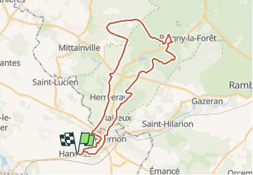

Length
35 km

Max alt
183 m

Uphill gradient
379 m
Km-Effort
40 km

Min alt
109 m

Downhill gradient
379 m
Boucle
Yes
Creation date :
2022-02-06 08:06:58.455
Updated on :
2022-02-06 11:00:29.439
2h52
Difficulty : Difficult

FREE GPS app for hiking
 SityTrail
IGN / Geographical institutes
SityTrail Plus
The world is yours!
About
Trail Mountain bike of 35 km to be discovered at Centre-Loire Valley, Eure-et-Loir, Hanches. This trail is proposed by topophil.
Positioning
Country:
France
Region :
Centre-Loire Valley
Department/Province :
Eure-et-Loir
Municipality :
Hanches
Location:
Unknown
Start:(Dec)
Start:(UTM)
400092 ; 5383829 (31U) N.
Comments