


cassie

Jean-Claude BOURGUE
User
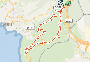

Length
12.1 km

Max alt
344 m

Uphill gradient
551 m
Km-Effort
19.5 km

Min alt
142 m

Downhill gradient
546 m
Boucle
Yes
Creation date :
2022-02-06 08:35:24.754
Updated on :
2022-02-06 14:43:07.971
3h53
Difficulty : Difficult

FREE GPS app for hiking
 SityTrail
IGN / Geographical institutes
SityTrail Plus
The world is yours!
About
Trail Walking of 12.1 km to be discovered at Provence-Alpes-Côte d'Azur, Bouches-du-Rhône, Cassis. This trail is proposed by Jean-Claude BOURGUE.
Positioning
Country:
France
Region :
Provence-Alpes-Côte d'Azur
Department/Province :
Bouches-du-Rhône
Municipality :
Cassis
Location:
Unknown
Start:(Dec)
Start:(UTM)
709493 ; 4788675 (31T) N.
Comments