


Toulaud

TOULAUDIN
User
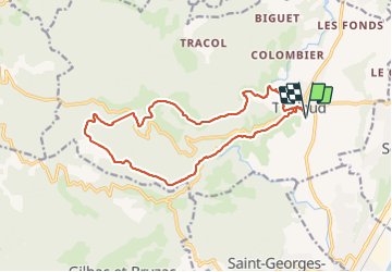

Length
16.3 km

Max alt
564 m

Uphill gradient
614 m
Km-Effort
25 km

Min alt
180 m

Downhill gradient
610 m
Boucle
Yes
Creation date :
2022-02-06 07:51:22.012
Updated on :
2022-02-06 15:00:59.123
5h41
Difficulty : Medium

FREE GPS app for hiking
 SityTrail
IGN / Geographical institutes
SityTrail Plus
The world is yours!
About
Trail Walking of 16.3 km to be discovered at Auvergne-Rhône-Alpes, Ardèche, Toulaud. This trail is proposed by TOULAUDIN.
Positioning
Country:
France
Region :
Auvergne-Rhône-Alpes
Department/Province :
Ardèche
Municipality :
Toulaud
Location:
Unknown
Start:(Dec)
Start:(UTM)
643641 ; 4972925 (31T) N.
Comments